


Canal de Castilla

This impressive piece of hydraulic engineering was built in the 18th and 19th century to get rid of surplus grain.
150 years later, this artificial river which flows 205km along the Meseta between the province[...]
Read more


General information
- Engineering and architecture of the Canal
Among the most important constructions of the Canal de Castilla there are the sluices. Their purpose was to avoid the unevenness of the ground as well as ease the navigation. They were additionally used to join two different sections of the Canal at different levels. The docks, constructed in stone, were used to load and unload merchandises. They are sort of ‘ports’ for this stretch of water.
Along the Canal, tourists find numerous bridges and a total of sixty-nine aqueducts, of varying size and length, as the Vallarna aqueduct or the aqueduct of Ucieza River, through which the barges navigated (at one time the number of barges managed to exceed 300) to transport merchandises along the Canal. On the other hand, dams and retentions were those that adjusted the bed of the Canal when it reached the Pisuerga and the Carrion Rivers.
Regarding the architecture of the Canal, firstly it has several warehouses: large and tall buildings built in the shipping area (docks). They were built to store goods and products like flour from the mills. Secondly there are the houses for the workers as well as the ones of the lock-keepers, generally constructed in adobe or brick; and finally, the windmills and flour mills. They were constructed to take advantage of the water force. Good examples of such buildings are the San Antonio flour mill in Medina de Rioseco, or the Abarca flour mill.
Moreover, the Canal has ‘arcas’ (small stone houses), built as a source of water supply for the irrigation channels, and for capturing and transporting water. The ‘postes leguarios’ are the milestones of the Canal de Castilla, the pillars that indicate the distance between the opposite ends of the branch. The irrigation towers are scattered in the whole tour of the Canal as it passes by the Northern and the Campos branches; they date from the 18th century and their purpose was to use the Canal not only as a form of irrigation but with navigation purposes too.
- History of the Canal
Although the idea to create a network of navigation channels had already been put forward in the 16th century, it was not until 1751 that it began to take shape when the Marques de la Ensenada requested it of Fernando VI.
The preliminary designs were done by Antonio Ulloa under the supervision of Carlos Lemaur. This French engineer had already worked on a project to build 7 canals. Ulloa, in 1753, drew up the so-called ‘Proyecto General de Navegacion y Riego’ para los Reinos de Castilla y León. The project included the construction of 4 canals, the 3 that exist today and a 4th one, the Canal de Segovia, which would have its source in the river Eresma and would flow into the river Duero at Villanueva de Duero.
On the 16th July 1753, work began officially on the Canal, beginning with the Ramal de Campos and ending in Medina de Rioseco in 1849. Work on the project was frozen for 2 years and during that time Antonio Ulloa and Lemaur passed up the chance to continue. Francisco Ibarrola as project co-ordinator and Fernando de Ulloa as engineer took over.
In 1792, when all three routes were still to be completed, trade navigation began along the Canal. In the same year, the Ramal del Norte and part of the Ramal de Campos to Paredes de Nava were opened. A few years later the Ramal del Sur began to operate.
Navigation along the Canal de Castilla reached its peak between 1850 and 1860. During that time almost 400 barges were using the Canal. Although most of these barges were used for transporting goods such as wheat, flour and wood, there were 4 used to transport passengers daily between Valladolid and Palencia.
When trains and railways came on the scene, traffic along the Canal gradually began to dwindle until there was a decree by the State for its closure in 1959. From that moment on, the Canal was only used for irrigation purposes.
- How to walk the Canal
One of the best ways to appreciate the nature, fauna and landscape that this area has to offer, is on foot.
It will take several days to cover the 200km distance that makes up the 3 branch roads of this route. Walking on average 25km or 30km per day, will be enough to complete the route in just under 8 days and enable hikers to enjoy the wonderful sights along the Canal de Castilla as well as the villages they pass through. All along the route various posters providing information on the different elements (docks, sluices, aqueducts etc...) of the route will appear. However the Canal is the best way to discover what there is to discover.
The Canal route can be done at any time of year. However, the best time is spring and summer. It is important to wear suitable clothing and to travel light. A raincoat in case of the odd shower and a cap for the sun are two recommended items.
The towpaths along the Canal allow also suitable for mountain biking. This is an ideal choice for taking in the monuments, landscape and fauna that this route offers. At an average speed of 10km per hour, 5 hours a day, cyclists will be able to complete the route in 4 days.
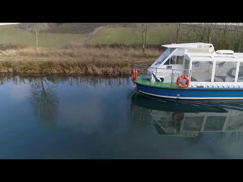
Activity holiday lovers can canoe along the Canal de Castilla. The tourists can sign up with one of the companies that organise these kind of canoeing trips. In addition, different routes can be made by boat along the Canal de Castilla, from Medina de Rioseco (Valladolid), Herrera de Pisuerga or Villaumbrales (Palencia) and Melgar de Fernamental (Burgos).