SO4 - Monte Valonsadero Trail
- Route code
- SO4
- Journey
- Circular
- Way
- On foot
- By bike
- Length
- 20 kms.
- Ascent slope
- 230 m.
- Difficulty of the route
- Medium-High
- Web
- To know more
Located on Monte Valonsadero next to Soria. It is the longest of the 5 routes announced on the information panel where the route begins and, therefore, also the one that crosses the most places of great beauty. The Vega de Baturio, the Azud de Buitrago, rock shelters, the Duero and Pedrajas rivers, oak forest, meadows for cattle grazing... are part of the route and the total of the natural wealth of landscape, geology, flora and fauna that contains Mt. Valonsadero belongs to the Soria City Council and has an area of 2,793 hectares.
Get to know the surroundings
Address and map location
- Postal address Toledillo (Soria). Soria
It's happening
- only 26 May
- When?
- Currently
- Dates
- May 26, 2026
- to12 August
- When?
- Currently
- Dates
- 14 May to 12 August 2026
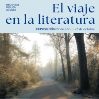
- to22 October
- When?
- Currently
- Dates
- 22 April to 22 October 2026
- only 27 May
- When?
- Soon
- Dates
- May 27, 2026
- only 27 May
- When?
- Soon
- Dates
- May 27, 2026
- only 28 May
- When?
- Soon
- Dates
- May 28, 2026
- only 29 May
- When?
- Soon
- Dates
- May 29, 2026
- only 29 May
- When?
- Soon
- Dates
- May 29, 2026
- only 4 June
- When?
- Soon
- Dates
- June 4, 2026
- only 5 June
- When?
- Soon
- Dates
- June 5, 2026