Batuecas and Sierra de Francia Natural Park
Image gallery
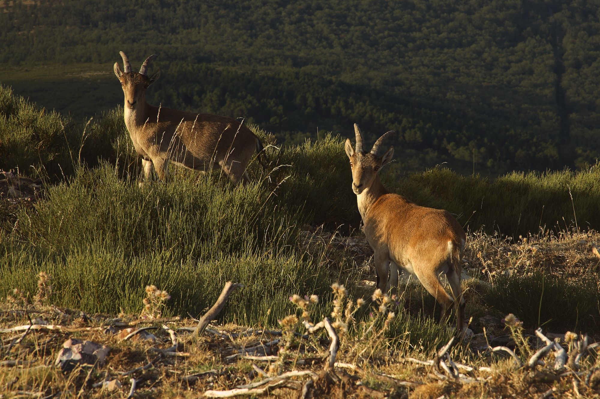
In Salamanca, on the border with Extremadura, discover a natural treasure. A space that protects in its caves and in the shelter of the valley an artistic legacy that whispers of human history. Explore caves such as La Batueca, Castañar, Caballos, Monedas and Risca, which house unique cave paintings from the Neolithic. Delve into vast forests of oak, chestnut and cork oaks, and explore valleys crisscrossed by streams and rivers. Observe deer, foxes, the elusive Iberian lynx among cistus and broom and the ibex, which, considered the emblematic species of Spanish hunting fauna, has its habitat on the slopes of the Peña de Francia.
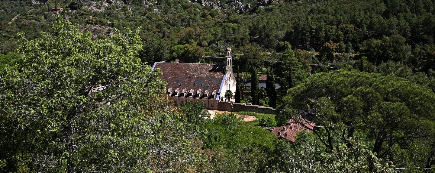
Located in the south of the province of Salamanca, very close to La Alberca, the Las Batuecas Valley is a magical place, a refuge for local fauna and a place chosen by some hermits for their retirement. Discover the Carmelite monastery of the San José Desert, founded at the end of the 17th century and recently restored and an ideal place for those seeking moments of meditation and serenity thanks to its inn.
Prepare your visit
Enviromental Areas
- wildlife
- Wild goat, roe deer, wild boar, and, above all, the Iberian lynx. Black vulture, golden eagle and Egyptian vulture also popular.
- Relief
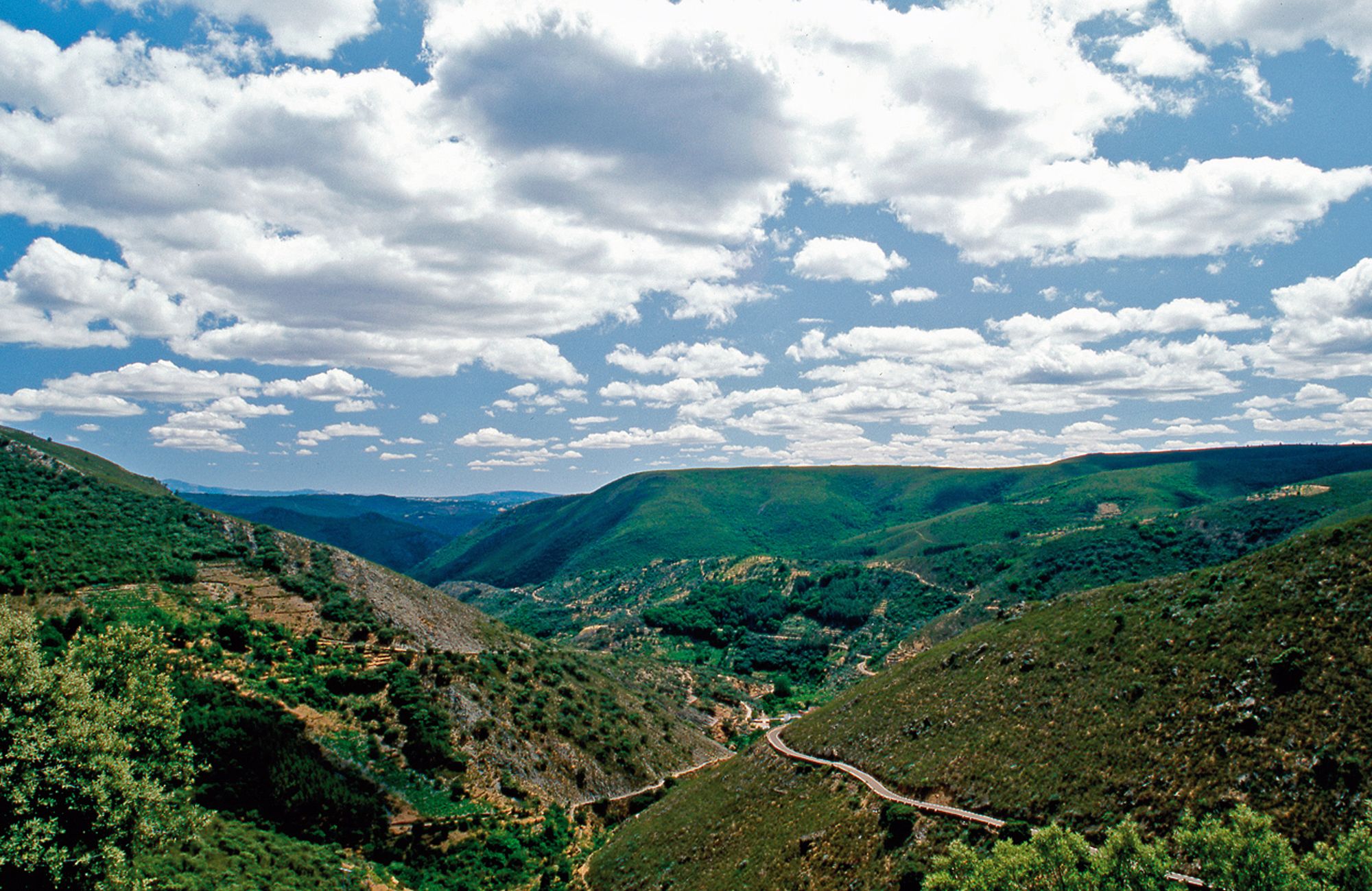
- Under the protection of the dramatic landscape of the Peña de Francia, there are many deep and isolated valleys with typical flora of the region.
- Vegetation
- True botanic garden with representations of all the species of the Mediterranean world.
Get to know this natural space
Park House of Batuecas-Sierra de Francia
The calendar of activities featuring all the major festivals and events will help visitors plan their stay. The welcoming Visitors’ Corner will also help them to plan their route using a map and model of the entire park.
On map
Address
- Postal address Ctra. Las Batuecas, 22. La Alberca. NaN. Salamanca
- Web
- Phones923 415 421
Enjoy this natural space
On foot and by bike
- PRSA-Senda accesible Accessible Pathway Valle de las BatuecasTo know more
This is a botanical path that shows us lots of species of forest and undergrowth of great beauty. Through the route, crossing its...
- Journey
- Linear
- Way
- On foot (0.2 h.)
- Length
- 1.5 kms.
- Difficulty of the route
- Low
- Asentadero - Forest of MirrorsTo know more
This route features some of the province of Salamanca’s stunning natural landscapes, taking visitors through charming towns and villages...
- Journey
- Circular
- Way
- On foot (3 h.)
- By bike (3 h.)
- Length
- 9.2 kms.
- Ascent slope
- 368 m.
- Recommended
- spring
- summer
- autumn
- winter
- Difficulty of the route
- Low
- PRSA-13 Cepeda-Herguijuela de la SierraTo know more
The journey passes through forests of oak and chestnut trees, following the course of the brook of San Pedro del Coso.
- Journey
- Linear
- Way
- On foot (3 h.)
- Length
- 12.6 kms.
- Ascent slope
- 80 m.
- Recommended
- spring
- summer
- autumn
- winter
- Difficulty of the route
- Low
- Cycle touring path Las CávenesTo know more
- Way
- By bike (2 h.)
- Length
- 16.12 kms.
- Ascent slope
- 250 m.
- Recommended
- spring
- autumn
- Difficulty of the route
- Medium-Low
- Cycle touring path Río AlagónTo know more
- Way
- By bike (1.5 h.)
- Length
- 16.5 kms.
- Ascent slope
- 200 m.
- Recommended
- spring
- summer
- autumn
- winter
- Difficulty of the route
- Medium-Low
- PRSA-8 El Cabaco- Peña de FranciaTo know more
It is not recommended to abandon the path on the slope of the rise of Peña de Francia, because it is a reserved area.
- Journey
- Linear
- Way
- On foot (6 h.)
- Length
- 8.7 kms.
- Ascent slope
- 760 m.
- Recommended
- spring
- summer
- autumn
- winter
- Difficulty of the route
- Medium
- PRSA-9 El Cabaco-Nava de Francia-El Casarito- Peña de FranciaTo know more
The route is not recommended with rain or snow. Footwear has to be comfortable. You must not leave the path on the slope leading...
- Journey
- Linear
- Way
- On foot (4.5 h.)
- By bike (4.5 h.)
- Length
- 11 kms.
- Ascent slope
- 760 m.
- Recommended
- autumn
- Difficulty of the route
- Medium-High
- Fossil Traces Route in MonsagroTo know more
The identity of Monsagro is related to the fossil traces that we easily discover on a good part of the facades of its houses, streets...
- Journey
- Circular
- Way
- On foot (1 h.)
- Length
- 1.5 kms.
- Recommended
- spring
- summer
- autumn
- winter
- Difficulty of the route
- Low
- PRSA-14 Herguijuela de la Sierra- La AlbercaTo know more
The route follows the upper part of the slope of the range of Honconera, enjoying almost all the way beautiful panoramics.
- Journey
- Linear
- Way
- On foot (6 h.)
- Length
- 8.1 kms.
- Ascent slope
- 460 m.
- Recommended
- spring
- summer
- autumn
- winter
- Difficulty of the route
- Medium
- GR-10 Journey of the Sierra de Francia, by the Laguna de San MarcosTo know more
High difficulty in some stretches.
- Journey
- Journey
- Way
- On foot (0.5 h.)
- Length
- 1.5 kms.
- Recommended
- spring
- summer
- autumn
- winter
- Difficulty of the route
- Low
- GR-10 (ETAPA 4) Journey of the Sierra de Francia, from La Alberca to the Peña de FranciaTo know more
High difficulty in some stretches. It is recommended not to climb Peña de Francia with snow.
- Journey
- Journey
- Way
- On foot (7 h.)
- Length
- 8.7 kms.
- Ascent slope
- 667 m.
- Recommended
- spring
- summer
- autumn
- winter
- Difficulty of the route
- Medium-High
- GR-10 (ETAPA 2) Journey of the Sierra de Francia, from Miranda to MogarrazTo know more
High difficulty in some stretches.
- Journey
- Journey
- Way
- On foot (2 h.)
- Length
- 5.6 kms.
- Ascent slope
- 260 m.
- Recommended
- spring
- summer
- autumn
- winter
- Difficulty of the route
- Medium
- GR-10 (ETAPA 3) Journey of the Sierra de Francia, from Mogarraz to La AlbercaTo know more
High difficulty in some stretches.
- Journey
- Journey
- Way
- On foot (2.5 h.)
- Length
- 7.6 kms.
- Ascent slope
- 306 m.
- Recommended
- spring
- autumn
- Difficulty of the route
- Medium
- GR-10 (ETAPA 5) Journey of the Sierra de Francia, from Monsagro to the recreation area El VaoTo know more
High difficulty in some stretches.
- Journey
- Journey
- Way
- On foot (1.5 h.)
- Length
- 3.5 kms.
- Recommended
- spring
- summer
- autumn
- winter
- Difficulty of the route
- Medium
- GR-10 Journey of the Sierra de Francia, from Sotoserrano to MirandaTo know more
High difficulty in some stretches.
- Journey
- Journey
- Way
- On foot (3.5 h.)
- Length
- 9.1 kms.
- Ascent slope
- 212 m.
- Recommended
- spring
- summer
- autumn
- winter
- Difficulty of the route
- Medium-High
- GR-10 (ETAPA 4) Journey of the Sierra de Francia, from the Peña de Francia to MonsagroTo know more
High difficulty in some stretches. It is recommended not to climb Peña de Francia with snow.
- Journey
- Journey
- Way
- On foot (6 h.)
- Length
- 12.5 kms.
- Recommended
- spring
- summer
- autumn
- winter
- Difficulty of the route
- Medium-High
- La Alberca - HerguijuelaTo know more
Along the route the varying orientation of different slopes, linked to the different degree of dampness caused by streams and springs,...
- Journey
- Journey
- Way
- On foot (3 h.)
- By bike (1.3 h.)
- Length
- 8.1 kms.
- Recommended
- spring
- summer
- autumn
- winter
- PRSA-10 La Alberca- Las Batuecas- Painted GoatsTo know more
This is a route quite hard and complicated. It is not allowed to leave the path in the valley of Batuecas or in Portillo because...
- Journey
- Linear
- Way
- On foot (4 h.)
- Length
- 8 kms.
- Ascent slope
- 650 m.
- Recommended
- spring
- summer
- autumn
- winter
- Difficulty of the route
- High
- PRSA-12 Mogarraz-CepedaTo know more
The route has a section that coincides with the ‘Ruta del Agua’, a path of art and nature where admire sculptures of various artists...
- Journey
- Linear
- Way
- On foot (1.5 h.)
- By bike (1.5 h.)
- Length
- 4.8 kms.
- Ascent slope
- 127 m.
- Recommended
- spring
- summer
- autumn
- winter
- Difficulty of the route
- Low
- PRSA-11 Monforte de la Sierra- Miranda del CastañarTo know more
The path is a walk through orchards of cherry trees, vineyards and olive trees. It is a comfortable journey with very nice views...
- Way
- On foot (2.5 h.)
- By bike (2.5 h.)
- Length
- 6.3 kms.
- Ascent slope
- 323 m.
- Recommended
- spring
- summer
- autumn
- winter
- Difficulty of the route
- Low
- Path of WondersTo know more
To the south of the province of Salamanca, in the Sierras de Béjar y de Francia Biosphere Reserve, is the Camino de los Prodigios.
- Journey
- Circular
- Way
- On foot (4 h.)
- Length
- 10.2 kms.
- Ascent slope
- 475 m.
- Recommended
- spring
- summer
- autumn
- winter
- Difficulty of the route
- Medium
- Ruta accesible (para personas con movilidad reducida) Pathway of the Castaños Centenarios Accessible PathwayTo know more
Apart from centenary chestnut trees, the path allows us to find ferns, hawthorns, broom, heather and other unique species.
- Journey
- Circular
- Way
- On foot (0.5 h.)
- Length
- 1.6 kms.
- Ascent slope
- 20 m.
- Recommended
- spring
- autumn
- Difficulty of the route
- Low
- Route of the three riversTo know more
The Three Rivers Route is a circular path, accessible to all audiences, that begins and ends in the Plaza Mayor de Sotoserrano. The...
- Journey
- Circular
- Way
- On foot (2.17 h.)
- Length
- 8.4 kms.
- Ascent slope
- 168 m.
- Recommended
- spring
- autumn
- Difficulty of the route
- Low
- SA1 SA1 - Path of the Roots (Paths of Art in Nature)To know more
Located in the Sierra de Francia. La Alberca has an interesting hiking route called "The Path of the Roots", it is one of the proposals...
- Journey
- Circular
- Way
- On foot
- Length
- 8 kms.
- Ascent slope
- 162 m.
- Difficulty of the route
- Low
- SA3 SA3 - Monforte de la Sierra - Miranda del CastañarTo know more
Located in Las Batuecas- Sierra de Francia Natural Park. The trail begins in Monforte de la Sierra and runs through cherry trees,...
- Journey
- Linear
- Way
- On foot
- Length
- 6.8 kms.
- Ascent slope
- 323 m.
- Difficulty of the route
- Low
- SA4 SA4 - "Batuecas Valley" Accessible TrailTo know more
Located in Las Batuecas- Sierra de Francia Natural Park. From the parking lot, a suspended wooden walkway next to the Batuecas River...
- Journey
- Linear
- Way
- On foot
- Length
- 1.5 kms.
- Ascent slope
- 700 m.
- Difficulty of the route
- Low
- SA5 SA5 - Path of the Centenary Chestnut Trees "Accessible Route"To know more
Located in Las Batuecas- Sierra de Francia Natural Park. This is an ideal path for people with physical disabilities, families or...
- Journey
- Circular
- Way
- On foot
- Length
- 1.6 kms.
- Ascent slope
- 20 m.
- Difficulty of the route
- Low
- PRCSA-15 The Dehesa de MogarrazTo know more
The road descends by a paved track that then returns to the original road of cobblestones, between terraces with cherry trees and...
- Journey
- Circular
- Way
- On foot (2 h.)
- Length
- 4 kms.
- Ascent slope
- 300 m.
- Recommended
- spring
- summer
- autumn
- winter
- Difficulty of the route
- Low
- Water WayTo know more
A path created with the passage of the centuries and an ideal place to explore a part of the Natural Park Las Batuecas - Sierra de...
- Journey
- Circular
- Way
- On foot (2.1 h.)
- By bike (2.1 h.)
- Length
- 6 kms.
- Ascent slope
- 255 m.
- Descent slope
- 255 m.
- Recommended
- spring
- summer
- autumn
- winter
- Difficulty of the route
- Low
- PRSA-19 Way Cepeda-Monforte de la SierraTo know more
The route is well signposted however must pay attention to the numerous walk diversions.
- Journey
- Linear
- Way
- On foot (1.5 h.)
- By bike (1.5 h.)
- Length
- 4.8 kms.
- Ascent slope
- 180 m.
- Recommended
- spring
- summer
- autumn
- winter
- Difficulty of the route
- Medium-Low
- PRSA-18 Way Herguijuela - Fuente MundoTo know more
The route is interesting to watch birds. In both sides of the road we observe pronounced gradients with remains of cork oaks, strawberry...
- Journey
- Linear
- Way
- On foot (0.75 h.)
- Length
- 2 kms.
- Ascent slope
- 120 m.
- Recommended
- spring
- summer
- autumn
- winter
- Difficulty of the route
- Low
- PRSA-20 Way circular de MadroñalTo know more
The route descends smoothly between orchards and strawberry trees.
- Journey
- Circular
- Way
- On foot (1.5 h.)
- Length
- 5 kms.
- Ascent slope
- 60 m.
- Recommended
- spring
- summer
- autumn
- winter
- Difficulty of the route
- Low
- Way of las raicesTo know more
Inside the Sierra de France the explorer will find this Camino de las Raíces, a tour of the art, nature and history of La Alberca,...
- Journey
- Circular
- Way
- On foot (2.75 h.)
- By bike (2.75 h.)
- Length
- 8 kms.
- Ascent slope
- 162 m.
- Descent slope
- 162 m.
- Recommended
- summer
- Difficulty of the route
- Low
- PRCSA-16 Way of los RodalesTo know more
The road passes by an agricultural trek, which takes us through orchards of vineyards and fruit trees, as well as small areas of...
- Journey
- Circular
- Way
- On foot (2 h.)
- By bike (2 h.)
- Length
- 6.5 kms.
- Ascent slope
- 80 m.
- Recommended
- spring
- summer
- autumn
- winter
- Difficulty of the route
- Low
- PRCSA-17 Way of the PeñascoTo know more
The route is easy and shows very important natural and archaeological finds.
- Journey
- Circular
- Way
- On foot (1 h.)
- Length
- 2 kms.
- Ascent slope
- 20 m.
- Recommended
- spring
- summer
- autumn
- winter
- Difficulty of the route
- Low