Montaña de Riaño and Mampodre Regional Park
Image gallery
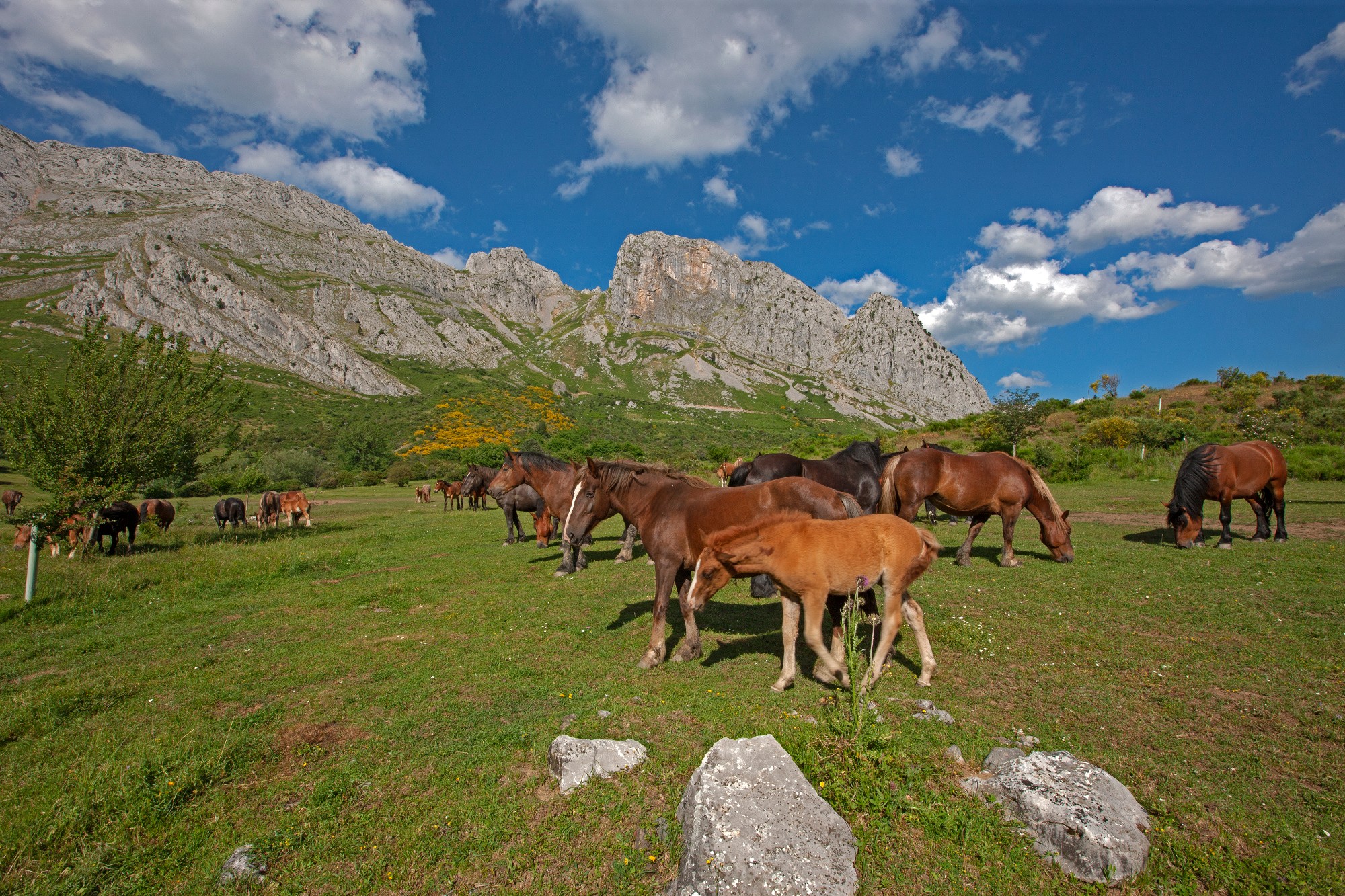
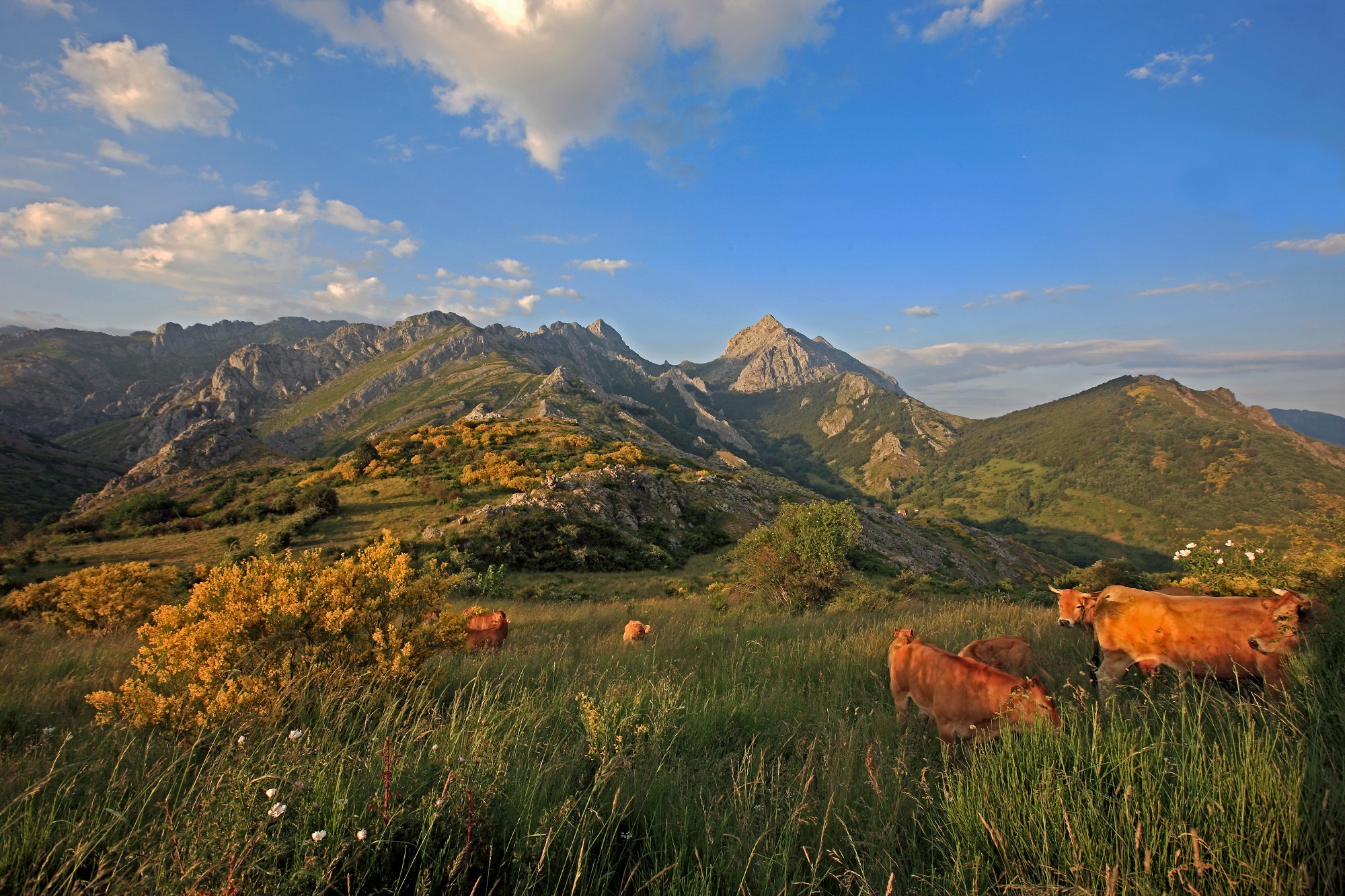
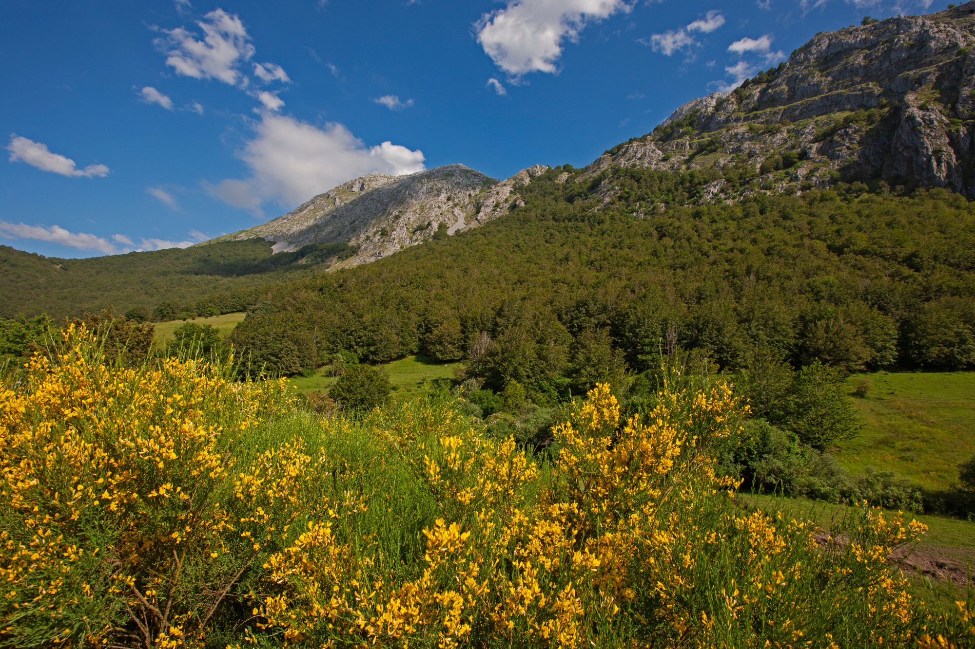
Located in the northeast of the province of Leon, this park covers an extensive high mountain territory of the Cantabrian Mountains, at the headwaters of the Esla, Porma and Cea rivers, and is part of the Picos de Europa mountain massif.
Discover a paradise of abrupt relief and marked altitude differences. Delve into the park's geographic diversity, where nestled valleys contrast with snow-capped peaks and glacial lakes. Follow the paths that wind through this landscape, immerse yourself in pure nature: riverside forests and majestic beech forests with changing colors.
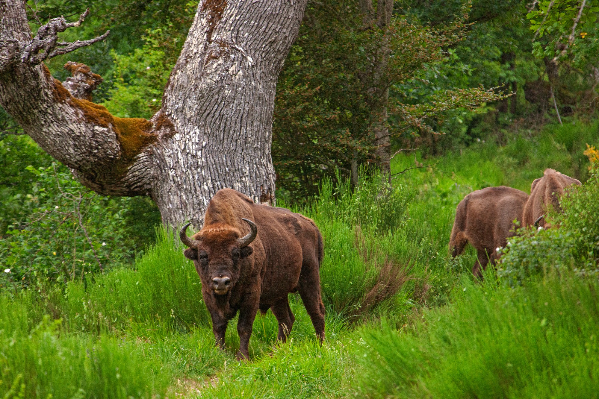
Emblematic species such as the brown bear, the capercaillie and the Iberian wolf coexist here, along with the enigmatic Bonelli's eagle. The alpine meadows dazzle with endemic species such as the Riaño violet and the Mampodre gentian. Towns like Llánaves de la Reina or Lois are ideal starting points to explore this corner of León, enveloping you in its rural charm and making your experience authentic.
Prepare your visit
Enviromental Areas
- wildlife
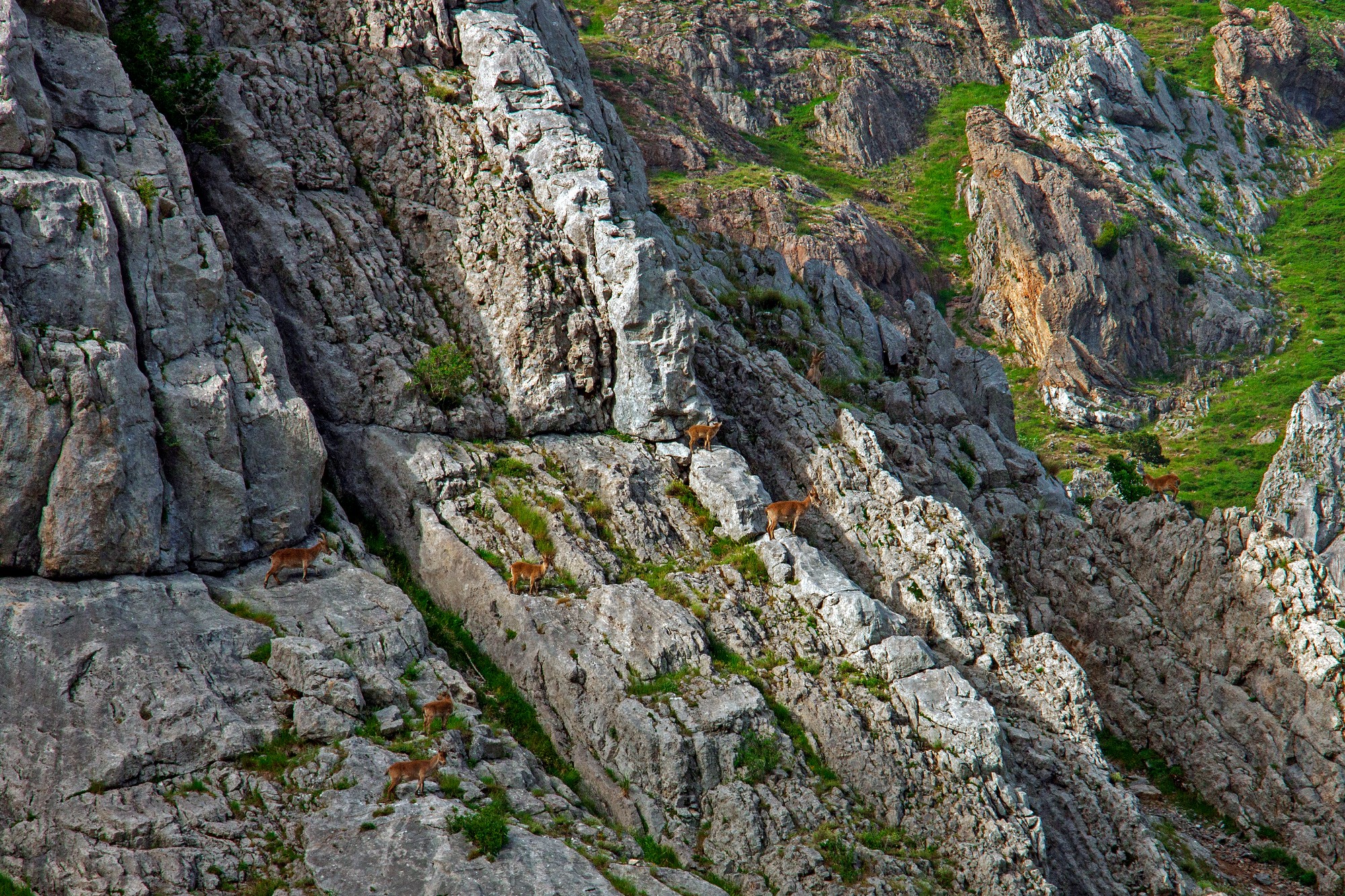
- The bear and capercaillie are the most representative species. Wolves, chamois, European badgers, otters, Bonelli's Eagle, Eurasian eagle-owl, Egyptian vulture and vautour percnoptère are some of its inhabitants.
- Relief
- A peculiar geological nature formed by a compact mass of limestone, broken and spectacular modeling. Its peculiar landscape is due to two types of erosion: glacier and karst.
- Vegetation
- The beech forms its main wooded mass. There are European holly, yew, chestnut, oak and birch also. Pinar de Lillo is a very interesting place but with a restricted access.
Get to know this natural space
House "El Torreón de Puebla de Lillo"
This Visitor Centre is housed in a medieval tower that over the centuries has witnessed the way the landscape, houses and people in this town have changed.
On the first floor is the reception area offering a general insight into the Regional Park and things...
On map
Address
- Postal address C/ La Torre, 2.. Puebla de Lillo. NaN. León
- Web
- Phones987 479 702
Prepare your visit
Park House of Valdeburon
The reception area offers visitors a general insight into the Regional Park, based on the general map and a brief audiovisual introduction featuring photographs that give an idea of what they can find.
Information is also available about the services provided...
On map
Address
- Postal address Ctra. Polvoredo, s/n. Lario (Burón). NaN. León
- Web
- Phones987 742 314
Prepare your visit
House "Valle del Porma"
This Visitor Centre is housed in a medieval tower that over the centuries has witnessed the way the landscape, houses and people in this town have changed.
On the first floor is the reception area offering a general insight into the Regional Park and things...
On map
Address
- Postal address C/ Félix Rodríguez de la Fuente, 9-11. Puebla de Lillo. NaN. León
- Web
- Phones987 479 701
Prepare your visit
Enjoy this natural space
On foot and by bike
- PR-LE 53 Cañadas Reales (Drovers' road) Leonesa OrientalTo know more
The route passes through an old road of possible Roman origin. You will find the ruins of a channel of water that fed a hydraulic...
- Journey
- Linear
- Way
- On foot (4 h.)
- Length
- 2 kms.
- Ascent slope
- 325 m.
- Difficulty of the route
- Medium
- PR-LE 52 Collado El BaileTo know more
In the way we will see beautiful Oakwood in which intermingle sessile oaks and gall oaks.
- Journey
- Circular
- Way
- On foot (3 h.)
- By bike (3 h.)
- Length
- 6.5 kms.
- Ascent slope
- 190 m.
- Recommended
- spring
- summer
- autumn
- winter
- Difficulty of the route
- Medium
- PR-LE 35 Corral de los LobosTo know more
The road has mountains of great sessile oaks. An old hut used for wolf hunting has been rebuilt.
- Journey
- Circular
- Way
- On foot (3 h.)
- By bike (3 h.)
- Length
- 7.8 kms.
- Ascent slope
- 312 m.
- Recommended
- spring
- summer
- autumn
- winter
- Difficulty of the route
- Low
- PR-LE 19 Door of the SeñalesTo know more
The route let us enjoy the short-toed Eagles and great diversity of amphibians in ponds of Las Señales port.
- Journey
- Circular
- Way
- On foot (2.3 h.)
- By bike (2.3 h.)
- Length
- 6.8 kms.
- Ascent slope
- 375 m.
- Recommended
- summer
- autumn
- Difficulty of the route
- Medium
- PR-LE 210 Door of the VentaniellaTo know more
The mound of Peña Castiello presents on its southern side, a vertical drop full of cavities.
- Journey
- Linear
- Way
- On foot (2 h.)
- By bike (2 h.)
- Length
- 4.7 kms.
- Ascent slope
- 227 m.
- Recommended
- spring
- summer
- autumn
- PR-LE 27 Entrevados-Valle de PinzonTo know more
The road crosses with Pinar de Lillo and beautiful waterfalls formed by Isoba River. It is dangerous to do this route with snow.
- Journey
- Linear
- Way
- On foot (5 h.)
- By bike (5 h.)
- Length
- 14.5 kms.
- Ascent slope
- 350 m.
- Recommended
- spring
- summer
- autumn
- winter
- Difficulty of the route
- Medium-High
- PR-LE 49 Four TownsTo know more
The route crosses several villages, each of which offers its own unique character and personality to the tourist. It is advisable...
- Journey
- Linear
- Way
- On foot (9 h.)
- By bike (9 h.)
- Length
- 20 kms.
- Ascent slope
- 320 m.
- Recommended
- spring
- summer
- autumn
- winter
- Difficulty of the route
- Medium
- GR 1 Historic Pathway, from Acebedo to Puerte de TarnaTo know more
The route access to the valley of Riosol, which shows magnificent fluvial terraces and large areas of grass.
- Journey
- Journey
- Way
- On foot (3.45 h.)
- Length
- 11.4 kms.
- Ascent slope
- 320 m.
- Recommended
- spring
- summer
- autumn
- Difficulty of the route
- Medium
- GR 1 Historic Pathway, from Las Salas to LoisTo know more
It is a very beautiful stretch, always on the banks of the fluvial channel and between high limestone walls.
- Journey
- Journey
- Way
- On foot (3.15 h.)
- Length
- 9.1 kms.
- Ascent slope
- 275 m.
- Recommended
- spring
- summer
- autumn
- Difficulty of the route
- Medium
- GR 1 Historic Pathway, from Lois to AcebedoTo know more
The path takes the detour that leads towards the pass that precedes the magnificent valley of Llorada, where there are still remains...
- Journey
- Journey
- Way
- On foot (3.15 h.)
- Length
- 9.1 kms.
- Ascent slope
- 415 m.
- Recommended
- spring
- summer
- autumn
- Difficulty of the route
- Medium
- GR 1 Historic Pathway, from Prioro to Las SalasTo know more
The way goes across the valley to the mount of Corral de los Lobos, where it has been rebuilt a snap as that might exist once.
- Journey
- Journey
- Way
- On foot (6.15 h.)
- Length
- 15.4 kms.
- Ascent slope
- 563 m.
- Recommended
- spring
- summer
- autumn
- Difficulty of the route
- Medium
- GR 1 Historic Pathway, from Valverde de la Sierra to PrioroTo know more
A part of the route goes by the side valley of the Valdicueva Brook. We will ascend on a path along the stream until we reach the...
- Journey
- Journey
- Way
- On foot (5.3 h.)
- Length
- 15.7 kms.
- Ascent slope
- 475 m.
- Recommended
- spring
- summer
- autumn
- Difficulty of the route
- Medium
- PR-LE 25 Horcadas PortsTo know more
Along the route we can see butterflies, especially in spring. In the ascent, right away, we find remains of two huts and their stone...
- Journey
- Circular
- Way
- On foot (2.5 h.)
- Length
- 6 kms.
- Ascent slope
- 450 m.
- Recommended
- spring
- summer
- autumn
- winter
- Difficulty of the route
- Medium
- PR-LE 33 Kills liceTo know more
The route lets the observation of roe deer and forest birds such as the middle spotted woodpecker, one of the most interesting species...
- Journey
- Linear
- Way
- On foot (2.5 h.)
- By bike (7.5 h.)
- Length
- 7.5 kms.
- Ascent slope
- 220 m.
- Recommended
- spring
- summer
- autumn
- winter
- Difficulty of the route
- Low
- L5 L5 - Cañadas Reales (Drovers' road) Leonesa OrientalTo know more
Located in the Montaña de Riaño and Mampodre Regional Park. The route begins by crossing the town of Prioro along Calle Real and...
- Journey
- Linear
- Way
- On foot
- Length
- 4 kms.
- Ascent slope
- 313 m.
- Difficulty of the route
- Medium
- L6 L6 - Monte Ranedo TrailTo know more
Located in the Montaña de Riaño and Mampodre Regional Park. The route begins in Lario, in front of the Casa del Parque de Valdeburón....
- Journey
- Circular
- Way
- On foot
- By bike
- Length
- 6.4 kms.
- Ascent slope
- 225 m.
- Difficulty of the route
- Low
- PR-LE 26 Lake AusenteTo know more
The route allows observing numerous mountain birds, like the Northern wheatear and the Common rock thrush. Accompanied by low scrub...
- Journey
- Linear
- Way
- On foot (1.3 h.)
- Length
- 2.9 kms.
- Ascent slope
- 350 m.
- Recommended
- summer
- Difficulty of the route
- Medium-High
- PR-LE 17 Lake of IsobaTo know more
The path that ends in the Isoba Lake, of glacial origin, passes by old mines of talc and by the fort of Castiltejon. Non recommended...
- Journey
- Linear
- Way
- On foot (2 h.)
- Length
- 6 kms.
- Ascent slope
- 270 m.
- Recommended
- spring
- summer
- autumn
- winter
- Difficulty of the route
- Low
- PR-LE 32 Liegos-AcebedoTo know more
This path allows the observation of several bird species; the most abundant is the yellowhammer. It is unadvisable to do this route...
- Journey
- Circular
- Way
- On foot (5.3 h.)
- By bike (5.3 h.)
- Length
- 15.4 kms.
- Ascent slope
- 455 m.
- Recommended
- spring
- autumn
- Difficulty of the route
- Medium
- PR-LE 47 Linares PortTo know more
The route allows you to see an old stone shepherd hut, including the dome-shaped ceiling. Non recommended during the snow period.
- Journey
- Circular
- Way
- On foot (2.3 h.)
- By bike (2.3 h.)
- Length
- 7.4 kms.
- Ascent slope
- 240 m.
- Recommended
- spring
- summer
- autumn
- Difficulty of the route
- Medium
- PR-LE 51 Llorada PortTo know more
In the ascension to the hill of Cerezales, the route crosses a beech forest where a beautiful insect dwells: the Rosalia longicorn.
- Journey
- Circular
- Way
- On foot (4 h.)
- By bike (4 h.)
- Length
- 8.4 kms.
- Ascent slope
- 350 m.
- Recommended
- spring
- summer
- autumn
- PR-LE 18 LoisTo know more
During the route we can see black kites and European honey buzzards. Some parts keep clumps of sessile oak and large Gall oaks.
- Journey
- Circular
- Way
- On foot (4 h.)
- By bike (4 h.)
- Length
- 9 kms.
- Ascent slope
- 450 m.
- Recommended
- spring
- summer
- autumn
- Difficulty of the route
- Medium
- PR-LE 29 Mampodre PeaksTo know more
The Oakwood of Torcedos shelters Eurasian sparrow hawks, Eurasian jays, great spotted woodpeckers, European green woodpeckers and...
- Journey
- Circular
- Way
- On foot (5 h.)
- Length
- 15.7 kms.
- Ascent slope
- 600 m.
- Recommended
- spring
- summer
- autumn
- Difficulty of the route
- Medium
- PR-LE 21 Mirva-RabanalTo know more
The route has beech trees where you can hear the black Woodpecker. The recreation area is located at the foot of antique limekilns.
- Journey
- Circular
- Way
- On foot (5 h.)
- Length
- 13 kms.
- Ascent slope
- 335 m.
- Recommended
- spring
- summer
- autumn
- Difficulty of the route
- Medium
- PR-LE 48 Monte la BoyeriaTo know more
The road has a singular polje, which is a valley that drains in a karstic sinkhole.
- Journey
- Circular
- Way
- On foot (2 h.)
- By bike (2 h.)
- Length
- 6 kms.
- Ascent slope
- 120 m.
- Recommended
- spring
- summer
- autumn
- Difficulty of the route
- Low
- PR-LE 31 Mount RanedoTo know more
This route is unadvisable with snow. In one of its meadows we can see a shepherds’ hut
’Pen included-, of artificial origin.
- Journey
- Circular
- Way
- On foot (2.15 h.)
- By bike (2.15 h.)
- Length
- 6.4 kms.
- Ascent slope
- 235 m.
- Recommended
- spring
- summer
- autumn
- Difficulty of the route
- Low
- Peña Prieta from Llánaves de la ReinaTo know more
The Fuentes Carrionas massif is one of the most important bastions of the Cantabrian Mountains, and its trilogy formed by the powerful...
- Journey
- Circular
- Way
- On foot (8 h.)
- Length
- 20 kms.
- Ascent slope
- 1,357 m.
- Descent slope
- 1,357 m.
- Recommended
- spring
- summer
- autumn
- Difficulty of the route
- High
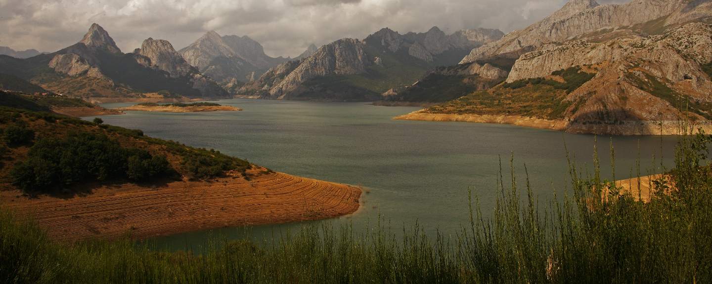
- PR-LE 51 Reservoir of PormaTo know more
- Journey
- Circular
- Way
- On foot (3.2 h.)
- Length
- 10.2 kms.
- Difficulty of the route
- Medium
- PR-LE 36 Royal WayTo know more
It is a historical route that connects the plateau with the mountain. The road passes through a peculiar forestry formation: the...
- Journey
- Linear
- Way
- On foot (10 h.)
- By bike (10 h.)
- Length
- 3.3 kms.
- Ascent slope
- 80 m.
- Recommended
- spring
- summer
- autumn
- Difficulty of the route
- Low
- PR-LE 24 San Glorio PortTo know more
The ascent to the San Glorio defile is marked by the inside of a reforestation of black pine.
- Journey
- Linear
- Way
- On foot (3 h.)
- Length
- 8.3 kms.
- Ascent slope
- 250 m.
- Recommended
- spring
- summer
- autumn
- Difficulty of the route
- Low
- Sierra del Jaido from ArgovejoTo know more
Surrounding the Leonese Riaño reservoir, sharp limestone ridges rise that create a spectacular dolomitic landscape where the mountaineer...
- Journey
- Circular
- Way
- On foot (6 h.)
- Length
- 12.6 kms.
- Ascent slope
- 1,050 m.
- Descent slope
- 1,050 m.
- Recommended
- spring
- summer
- autumn
- Difficulty of the route
- High
- Stage 6 - Section 6: Boñar - CistiernaTo know more
- Journey
- Linear
- Way
- By bike (2.5 h.)
- Length
- 25.3 kms.
- Ascent slope
- 210 m.
- Recommended
- spring
- summer
- autumn
- winter
- Difficulty of the route
- Medium
- Stage 6 - Section 6: Boñar - La VecillaTo know more
- Journey
- Linear
- Way
- By bike (1.05 h.)
- Length
- 9.3 kms.
- Ascent slope
- 100 m.
- Recommended
- spring
- summer
- autumn
- winter
- Difficulty of the route
- Medium
- Stage 6 - Section 7: Barrio de las Ollas - CistiernaTo know more
- Journey
- Linear
- Way
- By bike (2.58 h.)
- Length
- 26.8 kms.
- Ascent slope
- 210 m.
- Recommended
- spring
- summer
- autumn
- winter
- Difficulty of the route
- Medium
- Stage 6 - Section 7: Barrio de las Ollas - La VecillaTo know more
- Journey
- Linear
- Way
- By bike (1 h.)
- Length
- 7.8 kms.
- Ascent slope
- 90 m.
- Recommended
- spring
- summer
- autumn
- winter
- Difficulty of the route
- Medium
- PR-LE 23 Stream of OrpiñasTo know more
The Orpiñas brook flows at the foot of a limestone outcrop. This outcrop is affected by karstic processes which have given rise to...
- Journey
- Circular
- Way
- On foot (5 h.)
- Length
- 2 kms.
- Ascent slope
- 300 m.
- Recommended
- spring
- summer
- autumn
- Difficulty of the route
- Low
- PR-LE 50 Tejedo PortTo know more
The trail passes through a strait between the rocks, 'El Contadero’, which was used to register the flock. We will also find lichens...
- Journey
- Linear
- Way
- On foot (3 h.)
- Length
- 5.2 kms.
- Ascent slope
- 360 m.
- Recommended
- spring
- summer
- autumn
- Difficulty of the route
- Medium
- PR-LE 30 The BiescasTo know more
The route is not recommended with snow or rain. Passes near the houses of the Park of the Valley of Porma and Tower, both with the...
- Journey
- Linear
- Way
- On foot (6.3 h.)
- Length
- 3 kms.
- Ascent slope
- 285 m.
- Recommended
- summer
- Difficulty of the route
- Medium
- PR-LE 28 The CervatinaTo know more
Along the way, we can cross with wildlife. The flora is dominated by beeches although oaks, which attract attention by their imposing...
- Journey
- Circular
- Way
- On foot (5.3 h.)
- By bike (5.3 h.)
- Length
- 13.1 kms.
- Ascent slope
- 285 m.
- Recommended
- spring
- summer
- autumn
- Difficulty of the route
- Low
- PR-LE 34 TreesTo know more
The top of Arbillos is surmounted by four large stone pillars once used by shepherds to shelter from the cold and wind. There you...
- Journey
- Circular
- Way
- On foot (6 h.)
- Length
- 15.3 kms.
- Ascent slope
- 675 m.
- Recommended
- summer
- Difficulty of the route
- High
- PR-LE 22 Valley of Naranco-Valley of LechadaTo know more
Both valleys constitute a biological corridor of exceptional importance for the conservation of the last brown bears of the Eastern...
- Journey
- Linear
- Way
- On foot (6 h.)
- By bike (6 h.)
- Length
- 14.6 kms.
- Ascent slope
- 650 m.
- Recommended
- summer
- Difficulty of the route
- Medium
- PR-LE 54 Valverde de la Sierra- Barniedo de la SierraTo know more
The trail allows us to see blankets of Spanish junipers and magnificent gall oaks. The yellow-billed chough is typical. It is not...
- Way
- On foot (11.3 h.)
- By bike (11.3 h.)
- Length
- 5 kms.
- Ascent slope
- 390 m.
- Recommended
- spring
- summer
- autumn
- winter
- Difficulty of the route
- Medium
- PR-LE 46 Way of WambaTo know more
The road allows us to see a polje, a valley which empties into a karstic sinkhole, located in the place of the Fornos.
- Journey
- Linear
- Way
- On foot (1.3 h.)
- By bike (1.3 h.)
- Length
- 5.3 kms.
- Ascent slope
- 260 m.
- Recommended
- summer
- Difficulty of the route
- Low
Active Tourism activity search engine
Get to know the surroundings
Address and map location
It's happening
- only 25 July
- When?
- Soon
- Dates
- July 25, 2026
- only 17 August
- Dates
- August 17, 2026
- only 31 October
- Dates
- October 31, 2026